Save this image free of charge
in 800 pixels for layout use
(right click, Save as...)
|
|
Ref : V01961
Theme :
Looking at Earth - Rivers - lakes (517 images)
Title : Space Radar Image of Nile River Delta, Egypt
Caption :
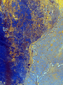
This spaceborne radar image shows the area just north of the city of Cairo, Egypt, where the Nile River splits into two main branches. The Rosetta Branch is the curving dark line in the center of the image and the Damietta Branch is the curving dark line in the lower right of the image. The light blue area on the right half of the image is a portion of the Nile River Delta. The thinner, straighter lines and the small network of gold lines are irrigation canals. There are more than 10,000 kilometers of canals throughout the Nile Delta. A transition zone of irrigated fields is shown in blue and yellow between the irrigated delta and the surrounding desert. The desert is the dark blue area on the left side of the image lacking the pattern of irrigated fields.This image was acquired by the Spaceborne Imaging Radar-C/X-band Synthetic Aperture Radar (SIR-C/X-SAR) on October 4, 1994, onboard the space shuttle Endeavour. The image is 75 kilometers by 60 kilometers (46 miles by 37 miles) and is centered at 30.2 degrees north latitude, 31.1 degrees east longitude. North is toward the upper right. The colors are assigned to different radar frequencies and polarizations as follows: red is L-band, horizontally transmitted and received; green is C-band, horizontally transmitted and received; and blue is the ratio of C-band and L-band, horizontally transmitted and received. SIR-C/X-SAR, a joint mission of the German, Italian and United States space agencies, is part of NASA's Mission to Planet Earth program.
|
|

